
|
Commenced:
|
01/07/2012 |
|---|---|
|
Submitted:
|
09/08/2012 |
|
Last updated:
|
15/01/2018 |
|
Location:
|
Chão Sobral, Aldeia das Dez - OHP - Coimbra, PT |
|
Climate zone:
|
Warm Temperate |
(projects i'm involved in)
Back to Mountain Steep Permaculture - Permacultura em Declive de Montanha
Project: Mountain Steep Permaculture - Permacultura em Declive de Montanha
Posted by João Gonçalves almost 14 years ago
Terraces
... on convex ridge and valley slopes.
http://en.wikipedia.org/wiki/Terrace_%28agriculture%29
"In agriculture, a terrace is a piece of sloped plane that has been cut into a series of successively receding flat surfaces or platforms, which resemble steps, for the purposes of more effective farming. This type of landscaping, therefore, is called terracing. Graduated terrace steps are commonly used to farm on hilly or mountainous terrain. Terraced fields decrease erosion and surface runoff, and are effective for growing crops requiring much water, such as rice."
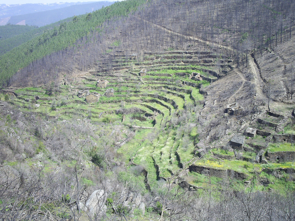
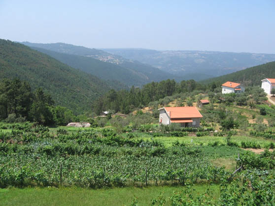
Pic 1 - Winter-Spring 2006. Central Portugal - Goshawk mountain range - Terraces and ruins of old houses and goat/sheep sheds.
The terraces on the left face south, in the centre face west, and on the right face south.
Part of the surrounding monocrop pinus pinaster forest was burnt during July 2005 forest fire.
It burnt in 1988 and went self sown after that to pinus again until 2005. From that it self sown again until the present.
At the bottom of the slope runs a creek where small "summer" moveable slate walled dams were built to hold water for maize and potatoe crops on the terraces.

Pic. 2 - Summer 1989. South facing terraces, on xist rocky steep ridge slope, some olive trees and xist houses and animal sheds. In these non irrigated terraces the grass turns yellow in the early summer... a rather brittle landscape, in "Holistic management" terms.
Pic. 3 - Winter 2004. South-west terraces in December, during the olives harvest. Yellow turns to green, pastures for sheeps and goats, both under olive trees or on maize fields, after harvest. Pinus pinaster trees on the ridge line above, with arbutus trees on the edge in between. Olive tress on the higher and west side terraces, non-irrigated plots. Small goat sheds, for groups of 3-8 animals in each, scattered on the terraced slope.
Maize fields after harvest are sown with rye during the first september rains, becoming rye grass pasture fields through the winter and early spring.
On the lower border of each terrace vines are grown supported by wooden stakes, or pole and wire rows.
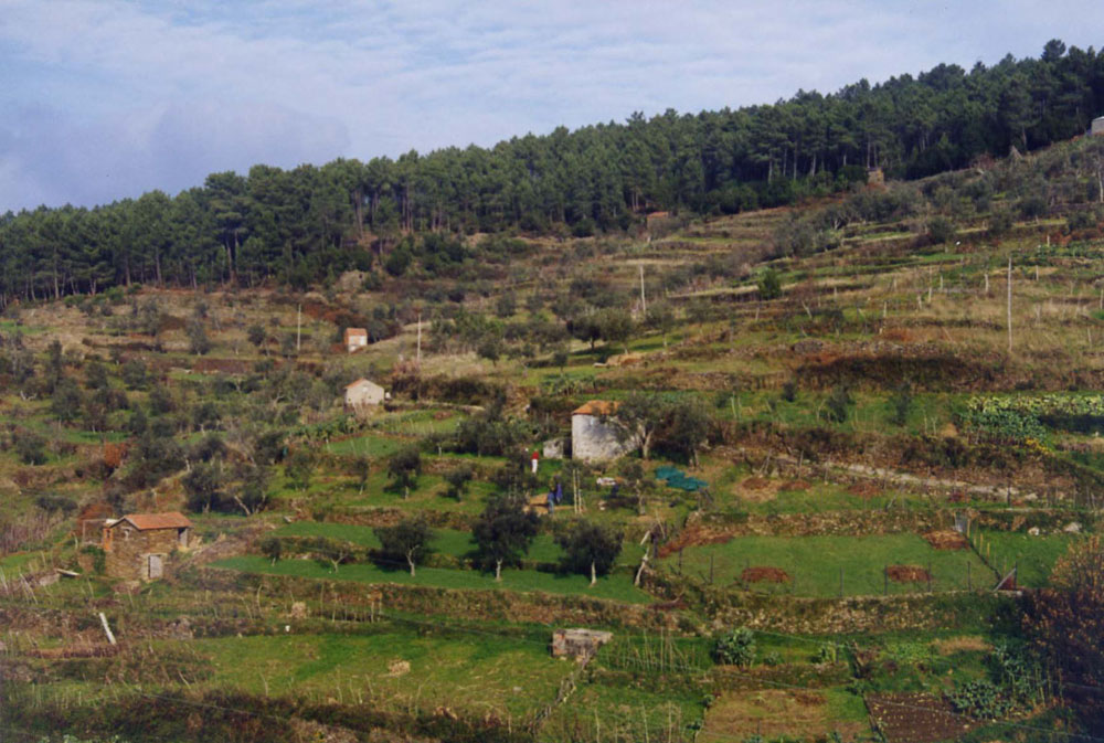
Pic. 4 - Spring 2004. South-west facing terraces in March-April. Heaps of manure in the center of some plots. A few plots were already tilled. Others are meadow or winter rye pasture. Forest of pinus pinaster, arbutus unedo and acacia dealbata above the terraced slope. Higher and drier - non irrigated - terraces planted with olive trees, and self sown meadow pasture under these.
Pic. 5 - Spring 2003.
Pic. 6 - Spring 2003.
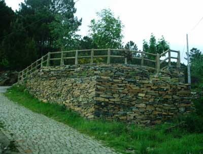
Pics. 5 and 6: The belvedere on the rocky ridge above the old village, stands on a terrace supported by xist stacked dry stone. It was built by two local dry stone wall builders with helpers. The grid is round pole treated pinus pinaster timber. This construction was organised by the local people's association "Progressive Union". 4 trees were planted for ornament and summer shade: plum on the lower terrace, maple, birch and sorbus on the higher terrace. Sorbus died after a few years, the other trees are growing well.
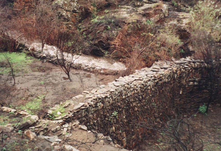
Pic. 7 - Winter-Spring 2006 - A rather level "large" terrace and 4-5 mts tall retaining wall on the right side of it, about 1mt thick, to hold and build soil where deep below was located the creek bed. The creek bed was moved aside using another 1mt width wall.
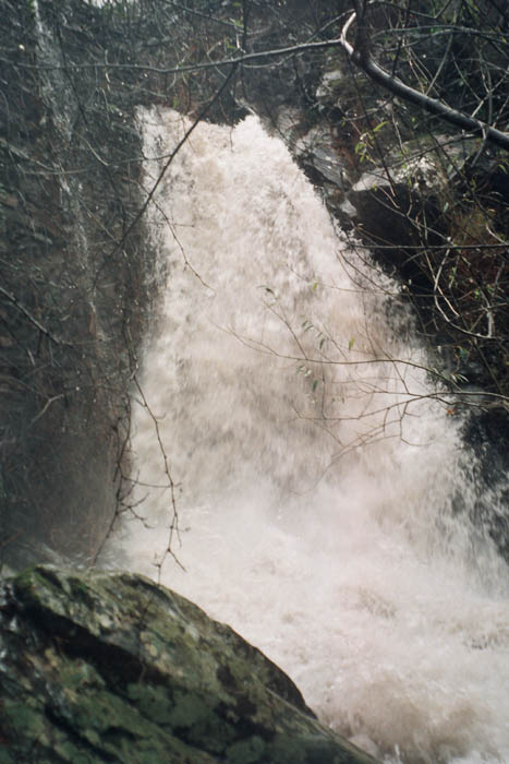
Pic. 8 - Winter-Spring 2006 - "Unnatural" waterfall, formed where a terrace about 7 mts retaining wall was built in the creek bed plus another 1 mt width dry stone wall was built to get the creek run on the south side of this terrace. An example of extreme river bed diversion to suit the need of increasing deep rich soil growing area in the sheltered microclimate bottom of the valleys.
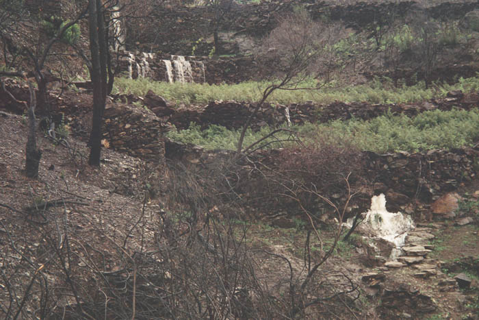
Pic. 9 - Winter-Spring 2006 - Terrace retaining walls were built in creek beds. After the forest fire waterfalls formed with the first big winter rains. Water channels underground were built and kept in the creek beds to move irrigation and storm water from higher to lower altitude terraces.
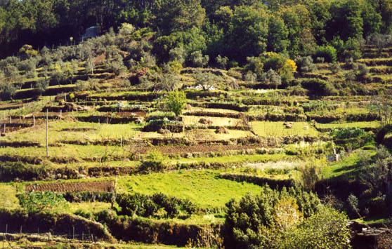
Pic. 10 - Summer 2004 - Looking towards west, a mosaic of different crops on the terraced convex slope landscape. Here we see grapevines in single rows on the edges over terrace reatining walls. Pasture, maize, potatoe, beans are typical crops of these Zone 2-3 terraces - these crops demand flood irrigation once or twice a week. The soil is fertile for about 20-40 cm deep, below that lies xist bedrock (used to build dry stack stone retaining walls), this condition makes this type of landform not suitable for agriculture, even though it has been used for it here for 100's of years, with our mountain farming methods ...
Pic. 11 - Spring 1993 - Almost all that is visible was burnt in the fire of 1988 and is in fast fire-resistant pioneer species regeneration.
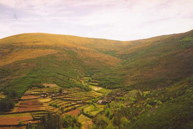
Terraces in context. The ridge line, convex slopes facing south west meeting in creek beds the slope facing north. Chestnut forest , castanea sativa - light green canopy trees -on the right - slope facing left-north. This area is located 500 mts south of Chao Sobral. The yellow color on the higher slope, above terraces, comes from genista spp, flowers, a shrub very drought tolerant, legume, rock friendly, used as coppice for biomass source, green manure and animal bedding, medicinal, as dry to start fire at home, among many other uses.
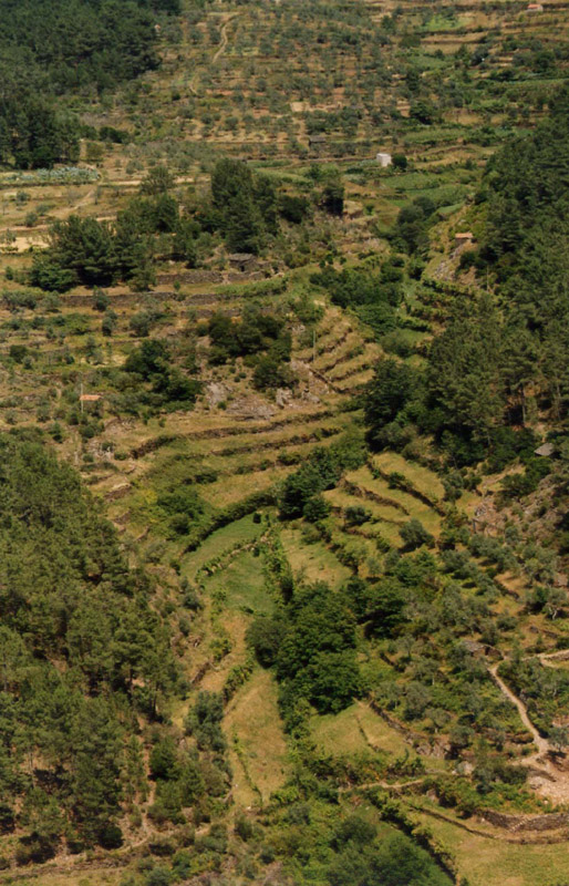
Pic. 12 - Summer 1997 - Almost from above view over the second biggest valley in Chão Sobral. Terraces were built aside the creek bed. The creek bed is located inbetween terraces retaining walls. In or near this creek bed there are a few water springs and this water is used to fill tiny dams built (logs and slate stone or planks, or with cement mortar and stone) in the beginning of the dry season and dismantled in the beginning of the wet season. In or near the creek bed grow figs, plums, apples, willows, chestnut, walnut trees. Along and on top the terrace retaining walls grow vines. In the "almost flat or less steep" area of terraced ground irrigated crops grow during the dry season, like corn, beans, pumpkin, potatoes. In the wet cold season grow brassicas, radishes, turnips. Pine trees and strawberry tree woodland on the left and in rocky outcrops patches. Olive trees - light grey green canopy on "less irrigated further away from dams" terraces both to the right and left. As people look for jobs most of these terraces turn to pasture where groups of 6 to 10 units of sheeps and goats graze for 2-3 hours per day maximum, in a rotational grazing regimes.
You must be logged in to comment.


Note: The various badges displayed in people profiles are largely honesty-based self-proclamations by the individuals themselves. There are reporting functions users can use if they know of blatant misrepresentation (for both people and projects). Legitimacy, competency and reputation for all people and projects can be evidenced and/or developed through their providing regular updates on permaculture work they’re involved in, before/after photographs, etc. A spirit of objective nurturing of both people and projects through knowledge/encouragement/inspiration/resource sharing is the aim of the Worldwide Permaculture Network.
 |
MemberA member is a permaculturist who has never taken a PDC course. These cannot become PDC teachers. Members may be novice or highly experienced permaculturists or anywhere in between. Watch their updates for evaluation. |
|---|---|
  |
Permaculture MatchmakerOne of these badges will show if you select your gender and the "I'm single, looking for a permaculture partner" option in your profile. |
 |
PDCPeople who claim to have taken a Permaculture Design Certificate (PDC) course somewhere in the world. |
 |
PDC VerifiedPeople who have entered an email address for the teacher of their PDC course, and have had their PDC status verified by that teacher. Watch their updates for evaluation. |
 |
PRI PDCPeople who’ve taken a Permaculture Research Institute PDC somewhere in the world. |
 |
PDC TeacherPeople who claim to teach some version of PDC somewhere in the world. |
 |
PRI TeacherWith the exception of the ‘Member’ who has never taken a PDC, all of the above can apply to become a PRI PDC Teacher. PRI PDC Teachers are those who the PRI recognise, through a vetting board, as determined and competent to teach the full 72-hour course as developed by Permaculture founder Bill Mollison – covering all the topics of The Designers’ Manual as well as possible (i.e. not cherry picking only aspects the teacher feels most interested or competent in). Such teachers also commit to focussing on the design science, and not including subjective spiritual/metaphysical elements. The reason these items are not included in the PDC curriculum is because they are “belief” based. Permaculture Design education concerns itself with teaching good design based on strategies and techniques which are scientifically provable. PRI PDC Teachers may be given teaching and/or consultancy offerings as they become available as the network grows. |
 |
Aid WorkerThe individual with this badge is indicating they are, have, or would like to be involved in permaculture aid work. As such, the individual may or may not have permaculture aid worker experience. Watch their updates for evaluation. |
 |
ConsultantThe individual with this badge is indicating they are, have, or would like to do paid permaculture design consultancy work. As such, the individual may or may not have permaculture consultancy experience. Watch their updates for evaluation. |
|
Community ProjectCommunity projects are projects that help develop sustainable community interaction and increase localised resiliency. |


")


