")
|
Commenced:
|
01/01/2014 |
|---|---|
|
Submitted:
|
04/03/2014 |
|
Last updated:
|
07/10/2015 |
|
Location:
|
5675 Majestiv View Rd SW, Deming, NM, US |
|
Website:
|
www.facebook.com/IslandofGreen |
|
Climate zone:
|
Hot Desert |
(projects i'm involved in)
Back to Island of Green (in the desert)
Project: Island of Green (in the desert)
Posted by Geert Cuypers over 12 years ago
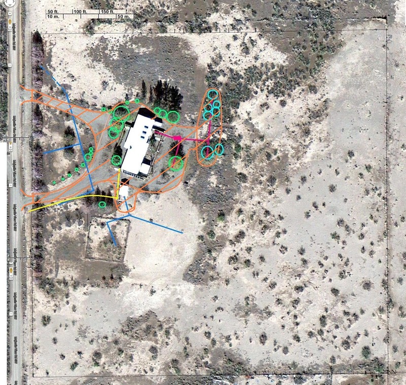
THE PLAN: From sandbox to Island of Green.
The picture below shows where we'll work and what we start with: a 10-acre sandbox.
legend of the colors used on the pictures:
orange: don't touch, taboo, protected area.
green circles = non-mesquite trees that are still alive.
azure circles = mesquite trees in the leach field
(there are many more unmarked outside the leach field)
purple lines = sewer line + leach field line
blue line = irrigation water line
yellow line = drain line for pool
black line = swale
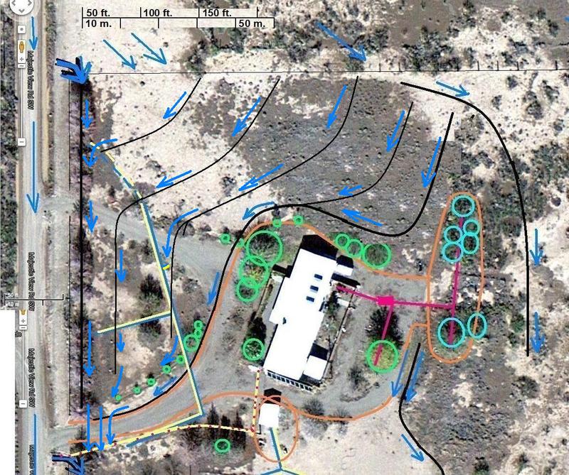
blue arrows = the overflow direction of the water.
======================
The ideas behind this project are simple:
Systematic water harvesting allows for diversification of vegetation (food forests), which leads to soil enrichment and natural pest control. Many different conservation techniques will be usefully applied and demonstrated in this project.
The end result has many advantages to the present situation:
• Stormwater harvesting = ground water conservation.
• Increased vegetation forms windbreaks that reduce soil erosion by wind and water.
• More diversified vegetation will improve the soil composition and land fertility, and will attract more wildlife and even support some production animals.
• The increased productivity of the land can be obtained without fertilizers or pesticides.
The Process:
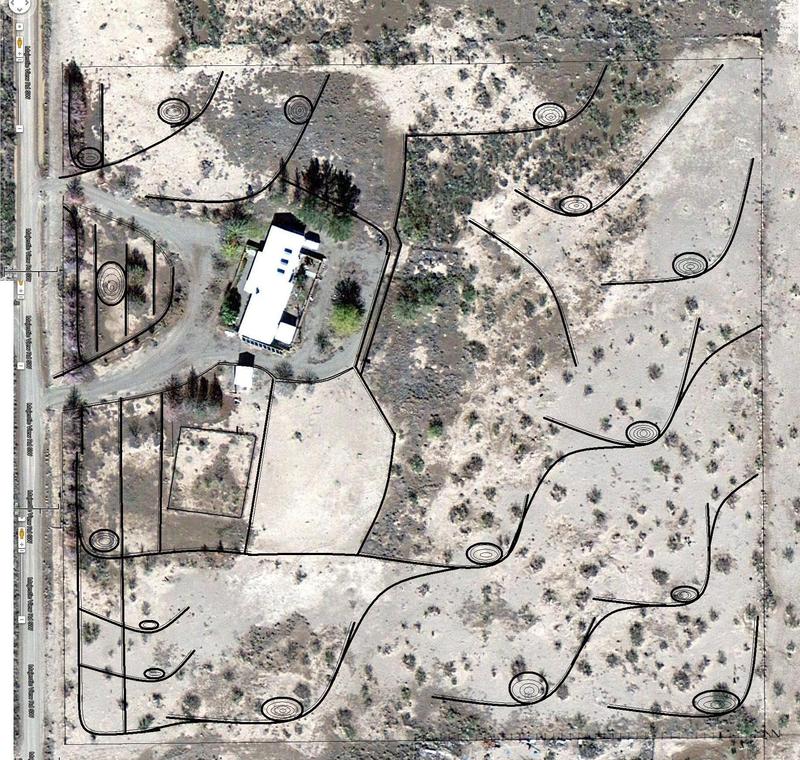
1. Swales (ditches) and water collection pits will be dug along contour lines. The swales capture water every time it rains (vernal pools) and force that water into the soil instead of allowing it to run off. (stormwater harvesting)
2. Organic matter like branches, compost, mulch, straw etc. will be used to fill the swales and cover the swale berms to lock in the moisture. (sheet mulching)
3. Micro-irrigation on the berms of the swales may be needed to help kick-start the system.
4. The swales need to be planted: (agroforestry, forest gardening)
a. 1st year with desert pioneer trees, cover crops, and a variety of bee forage plants;
b. 2nd + 3rd year with diverse food trees and undergrowth plants.
5. Animal use in the permaculture process:
a. Chickens in movable enclosures will organically prepare patches of soil between the swales for no-till crops. When done, the enclosure is moved to the next patch.
b. Goats in a movable enclosure (managed intensive rotational grazing) will manage the existing mesquite on the property by forcing it to grow upwards instead of sideways. That will maintain the native mesquite in the landscape, but will convert the current nuisance thorny shrubs into hardy shade trees.
c. Some collection pits will be lined or compacted to create permanent ponds. Pigs can be used to compact the soil in some of the water pits, so they will better hold their water. Hopefully that will create some permanent ponds that can be used to grow and harvest fish.
d. Bees can be captured from swarms or feral hives, but hive boxes will need to be purchased.
The Outcome will be a much improved self-sustainable landscape.
Instead of an unproductive sandbox that cannot currently support a single cow, there will be food forests and other vegetation that can support a variety of production animals, alternated with areas for food crops cultivation. The diversity in such system will improve soil quality over time without any chemical assistance.
A project like this would greatly improve the productivity of the land in an organic and sustainable manner, meaning that once established the system will renew itself without further maintenance.
====================
Planning + adapting
I have been putting out orange marker flags outside along the planned swale lines and after seeing things marked out like that, I have reconsidered some things from my first draft.
Instead of keeping the existing half-circle driveway, I'll make a single entrance access by closing off the upper driveway.
My reasons for doing so:
1. This will provide better privacy. Currently the house is wide open to the street.
The upper driveway looks directly at the house. That driveway will be closed, and be planted with trees. The lower driveway goes towards the side of the house, and the intended planting will block a direct view of the house.
2. High winds, and the dust storms that come with them, are a major problem here. An uninterrupted line of trees will provide better protection.
3. Without the upper driveway, it is a lot easier to lead the water from the NW corner of the property around and away from the house.
STAGE ONE of the new plan = the NW corner = about 30% of of the property.
The planned swales now cross the former upper driveway. Because there's hardly any drop on the property ( 2 to 3 ft over 280 yards diagonally NW to SE < .5%) it is extremely important to lead overflow around and away from the house to avoid flooding the house during severe thunderstorms.
Depending on how quick (or slow) this 1st stage goes, the rest of the work on the remainder of the property may have to wait until next year. Working in stages has some advantages:
1. It spreads the expenses and the work over a longer period.
2. Organization is easier if mulch and plants need not be obtained all at once for the entire project.
3. For teaching and promotion purposes, it is useful to be able to demonstrate different stages of progression of the project.
You must be logged in to comment.

Note: The various badges displayed in people profiles are largely honesty-based self-proclamations by the individuals themselves. There are reporting functions users can use if they know of blatant misrepresentation (for both people and projects). Legitimacy, competency and reputation for all people and projects can be evidenced and/or developed through their providing regular updates on permaculture work they’re involved in, before/after photographs, etc. A spirit of objective nurturing of both people and projects through knowledge/encouragement/inspiration/resource sharing is the aim of the Worldwide Permaculture Network.
 |
MemberA member is a permaculturist who has never taken a PDC course. These cannot become PDC teachers. Members may be novice or highly experienced permaculturists or anywhere in between. Watch their updates for evaluation. |
|---|---|
  |
Permaculture MatchmakerOne of these badges will show if you select your gender and the "I'm single, looking for a permaculture partner" option in your profile. |
 |
PDCPeople who claim to have taken a Permaculture Design Certificate (PDC) course somewhere in the world. |
 |
PDC VerifiedPeople who have entered an email address for the teacher of their PDC course, and have had their PDC status verified by that teacher. Watch their updates for evaluation. |
 |
PRI PDCPeople who’ve taken a Permaculture Research Institute PDC somewhere in the world. |
 |
PDC TeacherPeople who claim to teach some version of PDC somewhere in the world. |
 |
PRI TeacherWith the exception of the ‘Member’ who has never taken a PDC, all of the above can apply to become a PRI PDC Teacher. PRI PDC Teachers are those who the PRI recognise, through a vetting board, as determined and competent to teach the full 72-hour course as developed by Permaculture founder Bill Mollison – covering all the topics of The Designers’ Manual as well as possible (i.e. not cherry picking only aspects the teacher feels most interested or competent in). Such teachers also commit to focussing on the design science, and not including subjective spiritual/metaphysical elements. The reason these items are not included in the PDC curriculum is because they are “belief” based. Permaculture Design education concerns itself with teaching good design based on strategies and techniques which are scientifically provable. PRI PDC Teachers may be given teaching and/or consultancy offerings as they become available as the network grows. |
 |
Aid WorkerThe individual with this badge is indicating they are, have, or would like to be involved in permaculture aid work. As such, the individual may or may not have permaculture aid worker experience. Watch their updates for evaluation. |
 |
ConsultantThe individual with this badge is indicating they are, have, or would like to do paid permaculture design consultancy work. As such, the individual may or may not have permaculture consultancy experience. Watch their updates for evaluation. |
 |
Community ProjectCommunity projects are projects that help develop sustainable community interaction and increase localised resiliency. |

")