Logo primary
Logo secondary
S. Symens 's Profile
S. Symens
Details
Joined:
30/09/2011
Last Updated:
08/06/2015
Location:
Belgium
Climate Zone:
Cool Temperate


My Projects

(projects i'm involved in)


Projects

(projects i'm following)

Brin de Paille Permacultura Aralar GUANGA Permanente
Followers
bel mairo Carlo Makhoul Cindy Madou Corey Schmidt Crystal Rickerd Danes Denise Grant Diego Gutiérrez Flordeliza Harris Hubert de Kalbermatten Ilke Pedersen-Beyst Irene Kightley Jan Åberg Janus Bojesen Jensen Javier Cosp Jeff Higgins Jehan de Maille Kathryn Michaud Lee Edward Linda Morrison Lorenzo Costa Lorna Reay Marc Siepman MASMOUDI Soumia Mathieu Lefebvre Nick Rountree Rodney Robinson Ruud Hartmanns Samuel Lauwers Susan Cornish Tim Hamilton Vienne Guillaume
Following
Amy Weatherby-Johnson Andrea Proctor Ark L Bill Crandall Birthe Drews brian barnhart Campbell Burns Carolyn Holmes Cassidy Lackey Cecile van Berkum Chris Thomas Christine Bauer Cindy Madou Corey Schmidt Corinne Stockman Crystal Rickerd Danes Dan Grubbs Delia Rasmussen Denise Grant Diego Gutiérrez Eleanor Kelly Erik de Vries Fabian Hofstede Fatima Silva Franco Flordeliza Harris Geoff Lawton Ida Fay Ward Ilke Pedersen-Beyst Irene Kightley Jan Åberg Janus Bojesen Jensen Jeff Higgins Jehan de Maille Joel Sison Justin Hitt Kathryn Michaud Kevin Derheimer LÁszlo Wein Lee Edward Leisa Cox Lesley Byrne Linda Morrison Lorenzo Costa Lucas Magnalardo MASMOUDI Soumia Mason Reynolds Matt Powers MICHAEL LEONIDO Michael van Geemen Monika Frank view all(64)

Back to S. Symens's profile

Oh, to be a computer whiz...

Posted by S. Symens almost 9 years ago

My battle with contour, and that's just on paper!

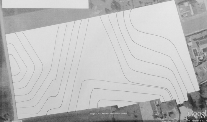
I struggled for several hours trying to make sense of the arcane instructions on how to get contour lines from Google Earth onto a map of my terrain using Sketchup, but I finally managed :-) 

A frustrating but ultimately rewarding exercise...

They're spaced at 20cm intervals. The highest point is on the left, the lowest top right, with less than 3 meters difference between them for a surface aread of 2.6 ha, not altogether that much!

Now I have to think (calculate!) how wide and deep, or rather shallow, I need the swales to be...

Screen shot 2015 07 11 at 00.55.40

Comments (10)

You must be logged in to comment.

Jehan de Maille
Jehan de Maille : hey Saskia.....i'd definitely be careful to NOT make a decision based on sketch up.....depending on the size of the plot and its degree of elevation....sketch up seems to go crazy.....1 easy reason is that g.earth is not THAT accurate on elevations.....for my exercice, i finally had to drop sketch up contour lines, they just did not make sense once on the terrain....(fairly flat land) you might want to use that a-frame, transit level or laser level before commiting to dig......
Posted almost 9 years ago

Report Jehan de Maille on Oh, to be a computer whiz...

Reason:

or cancel

Cindy Madou
Cindy Madou : Hi Saskia, may I conclude you've got the plot you talked about earlier ? If so congratulations! I must agree with Jehan that Google earth is not very accurate. If I should believe Google earth my property ends on a vertical wall with a hight of 2m, which is definitely not the case. But it was still useful to get a better idea of the larger area ... And you did gain some computer skills ;-)
Posted almost 9 years ago

Report Cindy Madou on Oh, to be a computer whiz...

Reason:

or cancel

S. Symens
S. Symens : Cindy, normally we should get it, the bank approved our loan, we're waiting for the notary to finalise the data :-D As far as I can judge it, not having access to the terrain until the deed is signed, the Google Earth Sketchup combination is more accurate than any topographical map I've seen so far, but of course, I will be checking my plans with an A-frame! Thanks for the warnings though, both of you!
Posted almost 9 years ago

Report S. Symens on Oh, to be a computer whiz...

Reason:

or cancel

Cindy Madou
Cindy Madou : Wow,spannend! In which area is it ? I'm a very curious person ;-)
Posted almost 9 years ago

Report Cindy Madou on Oh, to be a computer whiz...

Reason:

or cancel

Lorenzo Costa
Lorenzo Costa : Great to hear Saskia about the land. I ended up not using google earth it just didn't work well after one year of walking on the land I knew there were some things that were different. I used this link and method, try it: http://www.permies.com/t/35897/web-sites/Tutorials-permaculture-design-free-software especially read part 4 of the tutorial, its quite an easy system that was more accurate than just simply using sketch up. I'll admit that anyway I'm goingo to laser level everything this end of summer. I want to be sure I have the terraces and I want to be sure how they are built
Posted almost 9 years ago

Report Lorenzo Costa on Oh, to be a computer whiz...

Reason:

or cancel

Lorenzo Costa
Lorenzo Costa : http://www.permies.com/t/35897/web-sites/Tutorials-permaculture-design-free-software
Posted almost 9 years ago

Report Lorenzo Costa on Oh, to be a computer whiz...

Reason:

or cancel

Jan Åberg
Jan Åberg : If you think you need the fine details, you can ask a local geographer if there are laser-scannings available of your land. Because if that is the case you can use a GIS-software to extract very accurate contour lines (I use free software such as SAGA-GIS or Qgis). In my country (Sweden) the price for the laser-data ("Höjddata 2+") is very low in comparison to the amount of work required to measure the levels "by hand".

On small blocks of lands (such as your block), you should also try to use the simple tools suggested in the "Designers manual" when you do earth-works. Start in zone 1, and then let the pattern emerging in zone 1 show you how to design the details in zone 2 and so on. It will take more time, but is it wasted? I don't think so, because you'll also use the time for observation.
Posted almost 9 years ago

Report Jan Åberg on Oh, to be a computer whiz...

Reason:

or cancel

Corey Schmidt
Corey Schmidt : beautiful image : )
Posted almost 9 years ago

Report Corey Schmidt on Oh, to be a computer whiz...

Reason:

or cancel

S. Symens
S. Symens : Cindy, the land is located halfway between the cities of Leuven and Diest, in Vlaams-Brabant. Lorenzo, thanks for the link, I'm only now getting around to it! Thanks, Jan, these are all very sensible things to do. I like the organic approach too, starting from zone 1 and letting it grow... :-)
Posted over 8 years ago

Report S. Symens on Oh, to be a computer whiz...

Reason:

or cancel

S. Symens
S. Symens : Thank you everyone, for your good advice and legitimate warninfs! I finally redid all of the contour measurements with an A-frame: the Google earth ones were so wrong as to be unusable!
Posted over 3 years ago

Report S. Symens on Oh, to be a computer whiz...

Reason:

or cancel

My Permaculture Qualifications
Verified
PDC
Type: Permaculture Design Certificate (PDC) course
Teacher: Steve Read
Location: Noganets, France
Date: Sep 2011
Pri verified
Geoff Lawton
Type: Geoff Lawton Online PDC
Teacher: Geoff Lawton
Location: Online
Date: Feb 2015
Other course verified
Geoff Lawton
Type: Geoff Lawton Online Earthworks
Teacher: Geoff Lawton
Location: Online
Date: Feb 2015
Other course verified
Geoff Lawton
Type: Geoff Lawton Reading the Landscape
Teacher: Geoff Lawton
Location: Online
Date: Feb 2015

Report S. Symens

Reason:

or cancel

Hide S. Symens

Reason:

or cancel

Hide Oh, to be a computer whiz...

Reason:

or cancel

Report Oh, to be a computer whiz...

Reason:

or cancel